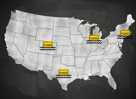
Floodwaters don’t wait for headlines, they upend lives overnight. Over the past week, four distinct regions across the U.S. were struck by intense and fast-moving floods that left homes submerged, small businesses damaged, and emergency crews scrambling. From New York’s urban chaos to Colorado’s rural overflows, these events reveal just how vulnerable American communities remain to sudden water disasters. Here’s a closer look at the week’s most impactful flood zones, starting with the one that paralyzed the Northeast.
1️⃣ Northeast I-95 Corridor Flooding (July 31 – August 1, 2025)
📍 Affected Areas:
- New York City, NY
- Northern New Jersey (including Hoboken, Newark)
- Southeastern Pennsylvania
- Mount Airy, Maryland
🌧️ What Happened:
A slow-moving storm system dumped 3 to 6 inches of rain in a matter of hours across heavily urbanized zones. With drainage systems overwhelmed and many cities unprepared for such a rapid deluge, flash floods took over streets, basements, and transit lines. The situation became so dire that both New York City and New Jersey issued emergency declarations.
In Mount Airy, Maryland, tragedy struck when a 13-year-old boy was swept away by floodwaters in a storm drain, a somber reminder of how fast these events can turn deadly.
🏠 Damage to Homes and Businesses:
- Hundreds of basement apartments and first-floor homes were flooded, particularly in Brooklyn and Hoboken.
- Small businesses. especially in low-lying retail zones and underpasses. suffered water intrusion and inventory loss.
- Many subway entrances flooded completely, disrupting millions of commutes and stalling deliveries.
- Power outages affected thousands, and some neighborhoods reported sewage backup due to overwhelmed treatment facilities.
🚨 Emergency Response:
- Emergency crews performed over 200 rescues across NYC and New Jersey.
- Pop-up emergency shelters opened in high-risk boroughs like the Bronx and Queens.
- Insurance companies began triage damage assessments by August 3, prioritizing dense commercial districts and multifamily homes.
🔍 Ongoing Risks:
- Mold remediation is expected to be a major issue, especially in NYC’s many unregulated basement units.
- Business continuity remains uncertain for smaller stores without flood insurance or digital inventory backups.
2️⃣ Minnesota Severe Storms & Flash Flooding (July 28–29, 2025)
📍 Affected Areas:
- Twin Cities metro (Minneapolis–St. Paul) and surrounding counties
- Stevens County (including Morris)
- Lyon County (Marshall)
🌧️ What Happened:
A powerful storm system swept across Minnesota on the nights of July 28 and 29, 2025, bringing intense rainfall, hail, flash flooding, and straight-line wind gusts of 60–76 mph, particularly in south-central parts like Rochester and Owatonna.
- Twin Cities saw rainfall rates reaching about 2 inches per hour, leading to flooded roadways like stalled cars on Highway 36 and inundated neighborhoods
- In Stevens County, Morris was hit by flash flooding with up to 2 feet of water on streets, prompting a flash flood warning until 9:15 p.m.
🏠 Impact on Homes & Businesses:
- In Marshall (Lyon County), a localized thunderstorm dropped an estimated 5–8 inches of rain within 2–3 hours, triggering flash flooding that inundated around 300 homes and businesses. Water entered basements, sewers backed up, and even the Avera hospital campus experienced flooding, forcing evacuations and reduced operations. Lyon County declared a state of emergency that night
- Across the Twin Cities metro, while commercial structures saw limited direct water damage, many streets flooded, cars stalled, and stormwater systems overflowed, causing road closures and utility strain
⚡ Power & Infrastructure Disruption:
- Over 140,000 Xcel Energy customers in the Twin Cities lost power due to downed trees and lines. Restoration crews expanded from 200 to over 500 technicians, but some areas remained in the dark for days
- Storms caused wind damage statewide and ongoing strain on stormwater infrastructure originally designed for much lighter seasonal rainfall patterns.
🔍 Key Observations:
- These storms formed part of a rapid succession of damaging events across Minnesota, compounding earlier flooding and weakening infrastructure.
- The flash flooding in Marshall stands out for its severity and direct impact to homes, local businesses (e.g., Dairy Queen flooded with a foot of water), and medical facilities, underscoring how sudden microburst rainfall events can devastate small towns.
3️⃣ Fort Lupton, Weld County, Colorado – Irrigation Canal Overflow (Early August 2025)
📍 Location:
- Near Fort Lupton in Weld County, northeastern Colorado.
🌧️ What Happened:
Heavy rainfall triggered an irrigation canal breach, causing water to overtop the canal banks and flood surrounding areas. Local officials reported flooding of roads, yards, and residential lots, though there has been no report yet of widespread structural collapse or business closures.
🏠 Impact on Homes & Businesses:
- Floodwaters extended into residential properties, inundating at least nine lots, according to Weld County briefings.
- Though detailed damage reports remain limited, water likely infiltrated yards, driveways, and outbuildings.
- There’s no confirmed reporting yet of main-floor damage to homes or business premises, suggesting most impact may be limited to secondary structures or yard flooding.
🚧 Infrastructure & Community Response:
- Road surfaces near the canal were submerged, prompting temporary closures.
- Emergency officials are assessing the canal’s structural integrity and monitoring for further risks.
- Weld County has high-level flood planning in place due to recurring irrigation and stormwater concerns.
🔍 Key Takeaways:
- This flood event appears to be localized and infrastructure-related, rather than driven by main-stem river overflow.
- The lack of reports about business disruptions suggests minimal commercial impact, at least so far.
- However, given historical flood context in Weld County (e.g. in the 2013 South Platte flood, where 350+ commercial properties and 3,000 homes were hit statewide) this event is being treated cautiously.
4️⃣ Texas Hill Country Catastrophic Flooding (July 4, 2025)
📍 Location:
- Kerr County, including Kerrville and recreational areas along the Guadalupe River.
- Neighboring counties like Kendall, Comal, and Bandera were also impacted.
🌊 What Happened:
On July 4, a sudden and historic deluge dumped 2–3 inches of rain per hour, causing the Guadalupe River to rise from base level to over 37 ft in just 45 minutes, a pace faster than all modern records in the region. This event triggered multiple Flash Flood Emergencies, with rainfall totals exceeding 20 inches in some parts of the watershed.
🏠 Impact on Homes & Businesses:
- The flooding damaged or destroyed 2,000+ structures, affecting homes, cabins, campgrounds, and summer‑camp facilities, including Camp Mystic, where at least 27 campers and counselors died.
- Thousands more residents were displaced, with water entering homes and businesses along river corridors.
- Total financial losses are estimated at $200 million, illustrating widespread disruption across even smaller communities.
🚨 Search, Rescue & Emergency Failures:
- More than 850 people were rescued during the initial flood response, including over 200 via helicopter, supported by at least 2,000 volunteer responders from across the country and Mexico.
- During a legislative hearing held on July 31, officials, including the county judge and emergency management coordinator—admitted they were asleep or absent as events unfolded. This lack of alertness and delayed warnings are believed to have contributed to the high death toll of over 135 people, including many children.
🛠️ Ongoing Recovery & Policy Response:
- Kerrville declared a Stage‑4 water supply emergency, implementing strict conservation measures after flood damage crippled its treatment plant. Some communities remain entirely reliant on groundwater wells.
- Cleanup operations in harder-hit areas like Kendall County began soon after, expected to last 8–10 weeks, with state funding covering initial costs and prioritized clearing of roads and river channels.
- At the same July 31 hearing, state lawmakers pressed for emergency reforms—proposing new legislation to fund flood warning systems, improve youth camp safety and modernize communication infrastructure. Lt. Gov. Dan Patrick pledged ongoing legislative progress.
🔍 Key Takeaways:
- This was one of the deadliest flash floods in U.S. history, with particularly heavy impacts on homes and recreational businesses in rural Texas.
- The tragedy exposed critical gaps in emergency warning systems and local preparedness, leading to calls for reform across infrastructure, process, and leadership.
- Community recovery is under way, but full rebuilding—both physical and institutional—is expected to take months or longer.
In just one week, floods hit big cities, small towns, and quiet rural areas. Each one left homes damaged, businesses closed, and lives changed. What stood out to me most was how quickly things went from normal to disaster. A few hours of rain turned streets into rivers and exposed how unprepared many communities still are. As we track recovery, we’ll be watching how support reaches those affected and whether lessons turn into action. Floods may come fast, but rebuilding takes time.